Royston (Iceni) Weather Station
Daily Weather Observations - SEPTEMBER 2006
(All Times GMT)
| Date | Max. Temp. (°C) 09/09h | Min. Temp. (°C) 09/09h | Grass Min. Temp. (°C) 21/09h | Earth (30cms) Temp. (°C) 09h | Sun (Hours) 00/00h | R'fall (MM) 09/09h | Wind Dir'n 09h | Mean Wind Speed (MPH) 00/00h | Max. Gust Speed (MPH) 00/00h | Cloud Cover (Oktas) 09h | Mean MSL Air Pressure (mB) 00/00h | Mean Rel. Humd. (%) 00/00h | Mean Temp. (°C) 00/00h | Fog (vis. <1000m @ 09h) | Fog (vis. <200m @ 09h) | Snow or Rain and Snow 00/00h | Snow Lying @ 09h (>50% cover) | Hail 00/00h | Thunder 00/00h | Date |
| 1 | 22.7 | 14.5 | 13.4 | 17.9 | 5.5 | TR | SW | 3.8 | 23 | 5 | 1010.4 | 82.7 | 18.1 | 0 | 0 | 0 | 0 | 0 | 0 | 1 |
| 2 | 21.8 | 14.0 | 12.8 | 18.0 | 0.1 | 0.4 | SW | 7.1 | 41 | 8 | 1004.7 | 88.6 | 16.8 | 0 | 0 | 0 | 0 | 0 | 0 | 2 |
| 3 | 25.1 | 17.1 | 15.6 | 17.8 | 8.7 | TR | SW | 9.2 | 46 | 7 | 1006.2 | 80.6 | 20.6 | 0 | 0 | 0 | 0 | 0 | 0 | 3 |
| 4 | 24.0 | 14.4 | 12.6 | 18.4 | 5.3 | 0.0 | W | 2.9 | 23 | 8 | 1019.9 | 76.4 | 18.8 | 0 | 0 | 0 | 0 | 0 | 0 | 4 |
| 5 | 24.4 | 18.3 | 17.0 | 19.0 | 4.6 | 0.0 | SW | 3.6 | 28 | 2 | 1019.7 | 77.0 | 21.2 | 0 | 0 | 0 | 0 | 0 | 0 | 5 |
| 6 | 26.5 | 17.2 | 15.0 | 19.0 | 9.3 | 0.4 | W | 2.4 | 21 | 1 | 1013.8 | 77.6 | 20.9 | 0 | 0 | 0 | 0 | 0 | 0 | 6 |
| 7 | 20.5 | 11.2 | 9.3 | 19.4 | 8.7 | 0.0 | N | 1.5 | 23 | 2 | 1020.3 | 75.3 | 15.0 | 0 | 0 | 0 | 0 | 0 | 0 | 7 |
| 8 | 21.7 | 7.2 | 4.6 | 18.2 | 12.2 | 0.0 | NE | 0.1 | 16 | 1 | 1028.4 | 76.8 | 13.8 | 0 | 0 | 0 | 0 | 0 | 0 | 8 |
| 9 | 21.1 | 7.6 | 5.0 | 17.6 | 11.7 | 0.0 | SE | 0.5 | 21 | 2 | 1023.6 | 79.0 | 14.1 | 0 | 0 | 0 | 0 | 0 | 0 | 9 |
| 10 | 26.1 | 8.4 | 5.6 | 17.2 | 12.0 | 0.0 | CALM | 1.0 | 16 | 0 | 1019.1 | 77.8 | 17.1 | 0 | 0 | 0 | 0 | 0 | 0 | 10 |
| 11 | 28.6 | 13.4 | 10.0 | 17.5 | 10.3 | 1.7 | SE | 1.2 | 21 | 2 | 1015.5 | 68.3 | 20.6 | 0 | 0 | 0 | 0 | 0 | 0 | 11 |
| 12 | 22.6 | 16.2 | 13.9 | 18.2 | 2.4 | 7.7 | SW | 0.4 | 14 | 7 | 1012.5 | 86.7 | 19.3 | 0 | 0 | 0 | 0 | 0 | 0 | 12 |
| 13 | 23.7 | 16.4 | 13.7 | 18.5 | 6.6 | 10.9 | S | 1.4 | 16 | 3 | 1006.2 | 89.4 | 19.6 | 0 | 0 | 0 | 0 | 0 | 1 | 13 |
| 14 | 22.5 | 16.0 | 15.0 | 18.7 | 5.2 | TR | SE | 1.8 | 25 | 7 | 1001.6 | 89.0 | 18.1 | 0 | 0 | 0 | 0 | 0 | 0 | 14 |
| 15 | 20.2 | 12.5 | 10.1 | 18.3 | 1.9 | 0.0 | N | 1.2 | 23 | 5 | 1007.9 | 93.1 | 16.0 | 0 | 0 | 0 | 0 | 0 | 0 | 15 |
| 16 | 20.5 | 15.4 | 15.3 | 18.2 | 0.1 | 0.0 | N | 0.3 | 14 | 8 | 1008.2 | 95.3 | 17.2 | 1 | 0 | 0 | 0 | 0 | 0 | 16 |
| 17 | 23.4 | 15.5 | 13.4 | 18.3 | 8.7 | 1.4 | SW | 0.7 | 14 | 6 | 1009.1 | 79.5 | 19.1 | 0 | 0 | 0 | 0 | 0 | 0 | 17 |
| 18 | 20.7 | 15.4 | 13.3 | 18.6 | 4.9 | 0.3 | SW | 3.5 | 28 | 8 | 1008.6 | 81.4 | 17.5 | 0 | 0 | 0 | 0 | 0 | 0 | 18 |
| 19 | 19.6 | 12.0 | 10.0 | 18.1 | 9.8 | 0.0 | W | 4.8 | 25 | 3 | 1010.1 | 72.5 | 15.4 | 0 | 0 | 0 | 0 | 0 | 0 | 19 |
| 20 | 22.6 | 10.6 | 8.9 | 17.4 | 10.4 | 0.0 | S | 5.1 | 37 | 2 | 1008.1 | 81.1 | 16.9 | 0 | 0 | 0 | 0 | 0 | 0 | 20 |
| 21 | 27.5 | 16.0 | 13.8 | 17.3 | 10.6 | 3.4 | SE | 4.4 | 28 | 0 | 1001.5 | 68.7 | 21.5 | 0 | 0 | 0 | 0 | 0 | 0 | 21 |
| 22 | 17.2 | 16.0 | 15.3 | 17.8 | 1.6 | 6.7 | SE | 1.3 | 16 | 8 | 1003.4 | 94.9 | 16.6 | 0 | 0 | 0 | 0 | 0 | 0 | 22 |
| 23 | 22.8 | 12.6 | 10.5 | 17.4 | 9.1 | 0.0 | SE | 0.3 | 14 | 6 | 1006.5 | 90.7 | 17.0 | 0 | 0 | 0 | 0 | 0 | 0 | 23 |
| 24 | 22.8 | 15.6 | 12.9 | 17.5 | 5.8 | 1.4 | S | 0.9 | 16 | 5 | 1002.5 | 86.1 | 18.3 | 0 | 0 | 0 | 0 | 0 | 0 | 24 |
| 25 | 17.6 | 15.0 | 12.6 | 17.6 | 0.0 | 4.1 | CALM | 0.2 | 12 | 8 | 1006.2 | 96.2 | 16.2 | 0 | 0 | 0 | 0 | 0 | 0 | 25 |
| 26 | 21.6 | 12.5 | 10.0 | 17.4 | 10.1 | 0.0 | W | 1.8 | 16 | 0 | 1014.0 | 83.4 | 15.9 | 0 | 0 | 0 | 0 | 0 | 0 | 26 |
| 27 | 20.2 | 11.4 | 9.5 | 17.0 | 3.6 | 0.0 | S | 4.7 | 28 | 8 | 1009.9 | 85.9 | 15.8 | 0 | 0 | 0 | 0 | 0 | 0 | 27 |
| 28 | 20.0 | 16.2 | 14.0 | 17.0 | 2.4 | 1.9 | SW | 3.0 | 25 | 4 | 1004.5 | 89.3 | 17.9 | 0 | 0 | 0 | 0 | 0 | 0 | 28 |
| 29 | 20.0 | 15.3 | 13.1 | 17.3 | 3.1 | 4.0 | S | 3.5 | 28 | 3 | 1001.1 | 93.9 | 16.4 | 0 | 0 | 0 | 0 | 0 | 0 | 29 |
| 30 | 20.2 | 11.2 | 9.0 | 17.2 | 7.4 | 0.3 | S | 2.6 | 23 | 4 | 1003.3 | 89.7 | 15.2 | 0 | 0 | 0 | 0 | 0 | 0 | 30 |
| Total/Mean | 22.3 | 13.8 | 11.8 | 17.9 | 191.7 | 44.6 | X | 2.5 | X | 4.4 | 1010.2 | 83.6 | 17.6 | 1 | 0 | 0 | 0 | 0 | 1 | Total/Mean |
| *Diff./% | +3.3 | +3.0 | 135% | 78% | *Diff./% | |||||||||||||||
| Date | Max. Temp. (°C) 09/09h | Min. Temp. (°C) 09/09h | Grass Min. Temp. (°C) 21/09h | Earth (30cms) Temp. (°C) 09h | Sun (Hours) 00/00h | R'fall (MM) 09/09h | Wind Dir'n 09h | Mean Wind Speed (MPH) 00/00h | Max. Gust Speed (MPH) 00/00h | Cloud Cover (Oktas) 09h | Mean MSL Air Pressure (mB) 00/00h | Mean Rel. Humd. (%) 00/00h | Mean Temp. (°C) 00/00h | Fog (vis. <1000m @ 09h) | Fog (vis. <200m @ 09h) | Snow or Rain and Snow 00/00h | Snow Lying @ 09h (>50% cover) | Hail 00/00h | Thunder 00/00h | Date |
Differences from average:
Differences from average shown in red. Reference periods used are as follows: Temperature 30 Years 1976/2005; rainfall 30 Years 1971/2000; sunshine 30 Years 1971/2000.
(*The differences from average quoted during the course of the month relate to the cumulative daily averages up to the date of the last observation, not the averages for the month as a whole)
Additional Data:
Rainfall Duration 31.7 hours
Air Frost Duration NIL hours
Graphs and Charts:
Click on the following links to view this month's graphs and charts.....
1. Daily Maximum, Minimum & Grass Minimum Temperatures
2. Daily Maximum & Minimum Temperatures (with 30 Year Comparative Means)
3. Daily Earth (30 cms Depth) Temperature @ 0900 GMT 4. Daily Rainfall 5. Daily Sunshine
6. Daily Maximum Gust & Mean Wind Speed 7. Daily Wind Direction @ 0900 GMT
8. Daily Mean MSL Air Pressure 9. Daily Mean Relative Humidity 10. Thermograph
11. Barograph 12. Hygrograph 13. Anemograph 14. Wind Direction
15. Sunshine Duration 16. Rainfall Intensity & Duration
September 2006 Weather Review:
......and click on the link below for a text report of the September 2006 weather in Royston
September (since 1972) at Royston (Iceni) Weather Station:
Mean day maximum temperature (30 years 1976/2005) 19.0°C
Mean night minimum temperature (30 years 1976/2005) 10.8°C
Highest temperature 29.6°C (5th September 1973); lowest temperature 2.0°C (22nd September 1979)
Lowest grass minimum temperature -1.4°C (30th September 1988)
Warmest September 1999 (Mean temperature 17.0°C); coolest September 1972 (Mean temperature 12.0°C)
Average September rainfall (30 years 1971/2000) 57.2 mm
Wettest September 1995 (Rainfall 138.7 mm); driest September 1996 (Rainfall 11.8 mm)
Wettest Day 22nd September 1992 (Rainfall 78.1 mm);
Highest number of "rain days" (0.2 mm or more) 21 (1974, 1995); lowest number of "rain days" 5 (1986)
Highest number of days with thunder 6 (1984)
|
|
|
|
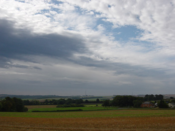
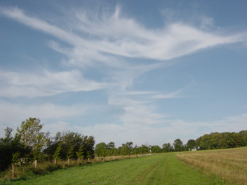
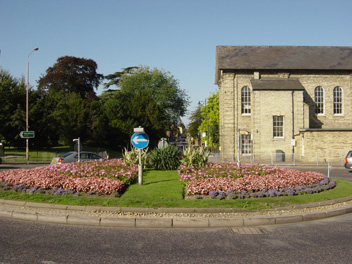
| From a vantage point close to Eagle Tavern 1.5 km SE of Royston this is the view southwards to the crest of the East Anglian Heights on the horizon at 0824 GMT on 1st September 2006. The sky looks somewhat threatening to the SE, but the intermittent rainfall which occurred in the 3 hours to 0730 GMT has now stopped and a dry day ensued. The photographer is facing a S wind of mean speed 2 knots gusting to 14 knots in a temperature of 16.3°C. The temperature later achieved a maximum of 22.7°C, whilst sunshine for the day was 5.5 hours. The former Eagle Tavern P. H. can just be seen near the right hand margin of the picture. | Another fine display of cirrus cloud occurred over Royston in the morning of 20th September 2006, this view from the Burloes estate to the SE of the town being seen at 0810 GMT. This cloud advanced ahead of a depression to the west of the British Isles but unusually instead of continuing its eastward movement it retreated westwards during the day to leave sunny skies over Royston. The trailing cold front of this low pressure system was latched on to by ex hurricane 'Gordon' then positioned to the west of the Iberian peninsula, and this combination was then responsible for bringing rainfall to Royston some 48 hours later. | Once again travellers on the A10 London to Kings Lynn road through the town of Royston this Summer have witnessed a fine display of flowers on the Town Hall roundabout. This is the view looking westwards (at 0902 GMT on 21st September 2006) towards Melbourn Street from a point adjacent to the now demolished old cinema which used to (along with the Town Hall) provide an imposing reference point by this junction. Part of the Town Hall itself is seen behind the roundabout. On this day the temperature achieved its highest value (27.5°C) for 21st September since at least 1972, the previous highest temperature for this date being 25.8°C in 1989. |
Return to Welcome to Royston (Iceni) Weather Station page
(This page last updated 9th October 2006 2001 GMT)