Royston (Iceni) Weather Station
Daily Weather Observations - February 2007
(All Times GMT)
| Date | Max. Temp. (°C) 09/09h | Min. Temp. (°C) 09/09h | Grass Min. Temp. (°C) 21/09h | Earth (30cms) Temp. (°C) 09h | Sun (Hours) 00/00h | R'fall (MM) 09/09h | Wind Dir'n 09h | Mean Wind Speed (MPH) 00/00h | Max. Gust Speed (MPH) 00/00h | Cloud Cover (Oktas) 09h | Mean MSL Air Pressure (mB) 00/00h | Mean Rel. Humd. (%) 00/00h | Mean Temp. (°C) 00/00h | Fog (vis. <1000m @ 09h) | Fog (vis. <200m @ 09h) | Snow or Rain and Snow 00/00h | Snow Lying @ 09h (>50% cover) | Hail 00/00h | Thunder 00/00h | Date |
| 1 | 12.0 | 7.1 | 3.1 | 5.9 | 5.6 | 0.0 | W | 1.1 | 14 | 1 | 1026.6 | 92.8 | 8.5 | 0 | 0 | 0 | 0 | 0 | 0 | 1 |
| 2 | 11.6 | 6.4 | 3.8 | 6.0 | 3.1 | 0.0 | W | 1.4 | 18 | 4 | 1031.7 | 89.0 | 6.9 | 0 | 0 | 0 | 0 | 0 | 0 | 2 |
| 3 | 9.3 | -0.1 | -5.4 | 5.9 | 8.0 | 0.0 | CALM | 0.0 | 2 | 0 | 1037.4 | 82.9 | 2.9 | 0 | 0 | 0 | 0 | 0 | 0 | 3 |
| 4 | 5.5 | -1.5 | -6.5 | 4.8 | 6.3 | 0.0 | CALM | 0.1 | 12 | 1 | 1029.3 | 94.9 | 1.3 | 0 | 0 | 0 | 0 | 0 | 0 | 4 |
| 5 | 4.2 | -0.9 | -1.2 | 4.4 | 0.7 | 0.6 | CALM | 0.0 | 7 | 4 | 1016.3 | 99.0 | 1.3 | 0 | 0 | 0 | 0 | 0 | 0 | 5 |
| 6 | 3.0 | -3.2 | -8.0 | 4.5 | 4.9 | 0.0 | W | 0.0 | 9 | 5 | 1005.4 | 88.3 | -0.8 | 0 | 0 | 0 | 0 | 0 | 0 | 6 |
| 7 | 4.0 | -4.9 | -10.4 | 3.8 | 7.4 | 5.0 | W | 0.1 | 9 | 0 | 999.1 | 91.1 | -1.1 | 0 | 0 | 0 | 0 | 0 | 0 | 7 |
| 8 | 1.4 | -1.6 | -5.8 | 3.3 | 0.0 | 3.0 | E | 0.1 | 16 | 8 | 987.8 | 96.1 | -0.0 | 0 | 0 | 1 | 1 | 0 | 0 | 8 |
| 9 | 5.5 | -0.6 | -0.5 | 3.0 | 0.0 | 6.3 | CALM | 0.2 | 21 | 8 | 999.7 | 98.3 | 1.2 | 1 | 0 | 0 | 1 | 0 | 0 | 9 |
| 10 | 9.4 | 3.0 | 2.1 | 3.0 | 0.0 | 10.9 | SE | 1.0 | 21 | 8 | 993.8 | 98.4 | 5.4 | 0 | 0 | 0 | 0 | 0 | 0 | 10 |
| 11 | 10.6 | 6.6 | 5.6 | 4.0 | 6.3 | 0.5 | SW | 5.7 | 32 | 7 | 987.9 | 90.4 | 8.3 | 0 | 0 | 0 | 0 | 0 | 0 | 11 |
| 12 | 10.0 | 7.0 | 5.0 | 4.9 | 0.6 | 3.6 | S | 6.2 | 35 | 6 | 983.5 | 93.6 | 7.3 | 0 | 0 | 0 | 0 | 0 | 0 | 12 |
| 13 | 8.6 | 5.9 | 3.5 | 5.4 | 4.2 | 4.7 | SW | 4.8 | 28 | 3 | 1002.1 | 85.9 | 7.0 | 0 | 0 | 0 | 0 | 0 | 0 | 13 |
| 14 | 9.1 | 6.5 | 6.0 | 5.7 | 2.9 | 0.5 | W | 3.2 | 25 | 8 | 1001.5 | 89.1 | 6.6 | 0 | 0 | 0 | 0 | 0 | 0 | 14 |
| 15 | 12.1 | 1.6 | -0.7 | 5.5 | 4.8 | 0.1 | S | 5.6 | 35 | 6 | 1013.4 | 86.1 | 6.2 | 0 | 0 | 0 | 0 | 0 | 0 | 15 |
| 16 | 9.3 | 5.6 | 4.0 | 5.5 | 0.6 | 0.0 | SE | 2.8 | 23 | 7 | 1007.6 | 85.1 | 7.1 | 0 | 0 | 0 | 0 | 0 | 0 | 16 |
| 17 | 10.9 | 1.1 | -2.5 | 5.6 | 4.7 | 0.0 | NW | 0.6 | 16 | 3 | 1009.2 | 94.1 | 5.6 | 0 | 0 | 0 | 0 | 0 | 0 | 17 |
| 18 | 7.9 | 4.6 | 0.8 | 6.0 | 0.0 | 0.0 | NE | 0.1 | 12 | 8 | 1015.9 | 95.2 | 6.3 | 0 | 0 | 0 | 0 | 0 | 0 | 18 |
| 19 | 10.9 | 5.9 | 5.5 | 6.4 | 1.1 | 0.6 | S | 1.7 | 18 | 8 | 1007.5 | 94.0 | 7.6 | 0 | 0 | 0 | 0 | 0 | 0 | 19 |
| 20 | 11.0 | 7.5 | 6.6 | 6.8 | 0.0 | 4.4 | S | 1.6 | 16 | 8 | 1004.0 | 97.6 | 9.1 | 0 | 0 | 0 | 0 | 0 | 0 | 20 |
| 21 | 11.4 | 7.2 | 5.6 | 7.3 | 6.4 | 0.7 | S | 2.1 | 23 | 2 | 1004.0 | 88.8 | 8.3 | 0 | 0 | 0 | 0 | 0 | 1 | 21 |
| 22 | 9.7 | 5.9 | 4.4 | 7.0 | 0.0 | 1.2 | S | 4.1 | 25 | 8 | 1000.5 | 97.2 | 8.1 | 0 | 0 | 0 | 0 | 0 | 0 | 22 |
| 23 | 12.4 | 7.0 | 4.5 | 7.3 | 3.1 | 5.1 | S | 4.1 | 28 | 5 | 995.2 | 93.4 | 9.0 | 0 | 0 | 0 | 0 | 0 | 0 | 23 |
| 24 | 10.3 | 7.5 | 5.6 | 7.5 | 0.2 | 10.8 | W | 3.4 | 23 | 8 | 989.7 | 94.0 | 8.6 | 0 | 0 | 0 | 0 | 0 | 0 | 24 |
| 25 | 10.5 | 4.8 | 4.4 | 7.9 | 0.7 | 0.0 | W | 3.3 | 25 | 7 | 993.4 | 92.9 | 7.4 | 0 | 0 | 0 | 0 | 0 | 0 | 25 |
| 26 | 10.1 | 6.4 | 4.0 | 7.9 | 3.8 | 2.9 | NW | 5.4 | 30 | 5 | 1010.5 | 78.6 | 6.6 | 0 | 0 | 0 | 0 | 0 | 0 | 26 |
| 27 | 12.3 | 3.0 | -1.3 | 7.4 | 0.0 | 0.8 | S | 8.0 | 41 | 8 | 1003.4 | 91.2 | 7.9 | 0 | 0 | 0 | 0 | 0 | 0 | 27 |
| 28 | 12.0 | 7.7 | 6.0 | 7.5 | 5.0 | 0.1 | SW | 13.8 | 53 | 4 | 988.7 | 78.5 | 9.5 | 0 | 0 | 0 | 0 | 0 | 0 | 28 |
| Total/Mean | 9.1 | 3.8 | 1.4 | 5.7 | 80.4 | 61.8 | X | 2.9 | X | 5.4 | 1005.2 | 91.3 | 5.8 | 1 | 0 | 1 | 2 | 0 | 1 | Total/Mean |
| *Diff./% | +1.9 | +2.0 | 111% | 177% | *Diff./% | |||||||||||||||
| Date | Max. Temp. (°C) 09/09h | Min. Temp. (°C) 09/09h | Grass Min. Temp. (°C) 21/09h | Earth (30cms) Temp. (°C) 09h | Sun (Hours) 00/00h | R'fall (MM) 09/09h | Wind Dir'n 09h | Mean Wind Speed (MPH) 00/00h | Max. Gust Speed (MPH) 00/00h | Cloud Cover (Oktas) 09h | Mean MSL Air Pressure (mB) 00/00h | Mean Rel. Humd. (%) 00/00h | Mean Temp. (°C) 00/00h | Fog (vis. <1000m @ 09h) | Fog (vis. <200m @ 09h) | Snow or Rain and Snow 00/00h | Snow Lying @ 09h (>50% cover) | Hail 00/00h | Thunder 00/00h | Date |
Differences from average:
Differences from average shown in red. Reference periods used are as follows: Temperature 30 Years 1976/2005; rainfall 30 Years 1971/2000; sunshine 30 Years 1971/2000.
(*The differences from average quoted during the course of the month relate to the cumulative daily averages up to the date of the last observation, not the averages for the month as a whole)
Additional Data:
Rainfall Duration 83.6 hours
Air Frost Duration 64.5 hours
Graphs and Charts:
Click on the following links to view this month's graphs and charts.....
1. Daily Maximum, Minimum & Grass Minimum Temperatures
2. Daily Maximum & Minimum Temperatures (with 30 Year Comparative Means)
3. Daily Earth (30 cms Depth) Temperature @ 0900 GMT 4. Daily Rainfall 5. Daily Sunshine
6. Daily Maximum Gust & Mean Wind Speed 7. Daily Wind Direction @ 0900 GMT
8. Daily Mean MSL Air Pressure 9. Daily Mean Relative Humidity 10. Thermograph
11. Barograph 12. Hygrograph 13. Anemograph 14. Wind Direction
15. Sunshine Duration 16. Rainfall Intensity & Duration
February 2007 Weather Review:
......and click on the link below for a text report of the February 2007 weather in Royston
February (since 1973) at Royston (Iceni) Weather Station:
Mean day maximum temperature (30 years 1976/2005) 7.2°C
Mean night minimum temperature (30 years 1976/2005) 1.8°C
Highest temperature 18.5°C (13th February 1998); lowest temperature -10.5°C (12th & 13th February 1985)
Lowest grass minimum temperature -14.5°C (10th February 1986)
Warmest February 1990 (Mean temperature 8.1°C); coldest February 1986 (Mean temperature -1.6°C)
Average February rainfall (30 years 1971/2000) 35.0 mm
Wettest February 2001 (Rainfall 90.7 mm); driest February 1998 (Rainfall 4.8 mm)
Wettest Day 7th February 2001 (Rainfall 21.8 mm);
Highest number of "rain days" (0.2 mm or more) 21 (2000); lowest number of "rain days" 5 (1998)
Highest number of days with thunder 2 (1995)
Highest number of air frosts 24 (1986)
Highest number of ground frosts 25 (1986)
Highest number of days with snow falling 15 (1986)
Highest number of days with snow lying (ground with more than 50% snow cover @ 0900 GMT) 23 (1986)
|
|
|
|
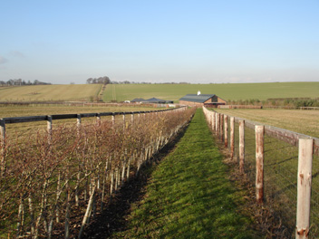
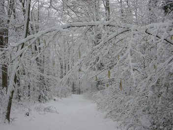
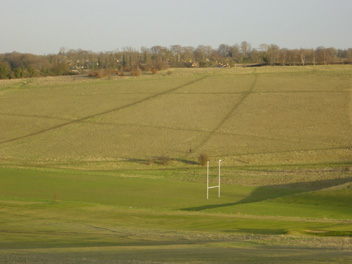
| In the wide sweep of landscape between Royston and the East Anglian Heights some 5 km to the south several stud farms with their attendant stables and paddocks have been developed in the last few years. Extensive planting of hedging along the paddock boundaries as shown in this picture of a diverted permissive footpath has also taken place. Curiously there are no horses visible in this picture, but they are around! The temperature is 2.5°C in calm conditions (at 1447 GMT on 6th February 2007) and this day was followed by the coldest night of the winter to date (minimum temperature -4.9°C). | The second snowfall 'event' of the winter occurred on 8th February 2007 and this was the winter wonderland scene observed (at 0930 GMT) in the Newmarket Road Plantation just beyond the eastern boundary of Royston. The view is looking downhill through the plantation from Hyde Hill. A level depth of snow of 9 cms was measured at 0900 GMT and snow was still falling at the time of this photograph. The temperature is -0.3°C and the calm conditions have undoubtedly helped the snow to settle on the twigs and branches of the trees and bushes. Most of this snow had thawed by the end of the next day. | Late afternoon sunshine is bathing Therfield Heath, Royston on 14th February 2007 (at 1618 GMT). This is the view as seen from high on the Heath looking eastwards towards the town. The rugby pitch can be seen in the dry valley which fans out from the golf driving range in the upper part of the valley. The 'noughts and crosses' appearance of the hillside beyond the valley illustrates the preferred routes of walkers across the 'springy' grass of this terrain. A gentle NW breeze of mean speed 1 knot gusting to 8 knots is drifting across the Heath from the adjacent South Cambridgeshire plain (temp. 8.1°C). |
Return to Welcome to Royston (Iceni) Weather Station page
(This page last updated 9th March 2007 2137 GMT)