Royston (Iceni) Weather Station
Daily Weather
Observations - June
2007
(All Times GMT)
| Date |
Max.
Temp. (°C) 09/09h |
Min.
Temp. (°C) 09/09h |
Grass
Min. Temp. (°C) 21/09h |
Earth
(30cms) Temp. (°C) 09h |
Sun
(Hours) 00/00h |
R'fall
(MM) 09/09h |
Wind
Dir'n 09h |
Mean
Wind Speed (MPH) 00/00h |
Max.
Gust Speed (MPH) 00/00h |
Cloud
Cover (Oktas) 09h |
Mean
MSL Air Pressure (mB) 00/00h |
Mean
Rel. Humd. (%) 00/00h |
Mean
Temp. (°C) 00/00h |
Fog
(vis. <1000m @ 09h) |
Fog
(vis. <200m @ 09h) |
Snow
or Rain and Snow 00/00h |
Snow
Lying @ 09h (>50% cover) |
Hail
00/00h |
Thunder
00/00h |
Date |
| 1 |
22.4 |
7.0 |
3.5 |
14.5 |
15.3 |
0.0 |
NE |
0.2 |
12 |
1 |
1015.5 |
73.5 |
15.3 |
0 |
0 |
0 |
0 |
0 |
0 |
1 |
| 2 |
24.1 |
9.0 |
5.1 |
15.5 |
15.8 |
0.0 |
NE |
0.1 |
9 |
0 |
1022.0 |
66.8 |
17.4 |
0 |
0 |
0 |
0 |
0 |
0 |
2 |
| 3 |
23.5 |
11.0 |
7.7 |
15.6 |
14.9 |
0.1 |
SE |
0.1 |
12 |
0 |
1020.5 |
76.3 |
17.4 |
0 |
0 |
0 |
0 |
0 |
0 |
3 |
| 4 |
21.0 |
11.1 |
9.4 |
17.4 |
3.7 |
0.4 |
N |
0.7 |
18 |
8 |
1021.9 |
86.5 |
14.9 |
0 |
0 |
0 |
0 |
0 |
0 |
4 |
| 5 |
20.7 |
10.8 |
8.3 |
16.9 |
5.9 |
0.0 |
N |
2.4 |
21 |
7 |
1021.9 |
86.6 |
14.3 |
0 |
0 |
0 |
0 |
0 |
0 |
5 |
| 6 |
14.2 |
10.4 |
10.2 |
17.5 |
0.0 |
1.0 |
NE |
2.0 |
18 |
8 |
1019.8 |
87.6 |
12.0 |
0 |
0 |
0 |
0 |
0 |
0 |
6 |
| 7 |
17.2 |
11.3 |
11.1 |
16.7 |
0.0 |
TR |
NE |
1.0 |
16 |
8 |
1018.4 |
96.4 |
13.1 |
0 |
0 |
0 |
0 |
0 |
0 |
7 |
| 8 |
19.2 |
11.2 |
11.2 |
16.4 |
3.8 |
0.0 |
N |
0.1 |
12 |
8 |
1017.4 |
92.2 |
14.1 |
1 |
0 |
0 |
0 |
0 |
0 |
8 |
| 9 |
25.0 |
13.5 |
10.9 |
16.5 |
9.7 |
0.0 |
N |
0.1 |
12 |
6 |
1016.0 |
80.3 |
18.9 |
0 |
0 |
0 |
0 |
0 |
0 |
9 |
| 10 |
22.0 |
11.1 |
9.5 |
17.8 |
5.3 |
TR |
NE |
0.2 |
14 |
8 |
1014.5 |
86.8 |
16.4 |
0 |
0 |
0 |
0 |
0 |
0 |
10 |
| 11 |
18.5 |
13.5 |
12.5 |
18.4 |
0.9 |
0.0 |
N |
0.1 |
9 |
8 |
1012.5 |
91.9 |
15.3 |
0 |
0 |
0 |
0 |
0 |
0 |
11 |
| 12 |
22.2 |
14.1 |
11.0 |
17.5 |
5.2 |
0.0 |
W |
2.3 |
21 |
8 |
1007.8 |
81.6 |
18.2 |
0 |
0 |
0 |
0 |
0 |
0 |
12 |
| 13 |
23.4 |
13.1 |
11.5 |
18.0 |
5.9 |
5.4 |
W |
1.3 |
16 |
3 |
1004.1 |
76.7 |
18.2 |
0 |
0 |
0 |
0 |
0 |
1 |
13 |
| 14 |
21.0 |
14.5 |
14.3 |
18.4 |
0.0 |
11.4 |
NE |
0.1 |
12 |
8 |
999.4 |
92.5 |
17.1 |
0 |
0 |
0 |
0 |
0 |
1 |
14 |
| 15 |
21.9 |
15.4 |
15.2 |
18.4 |
6.4 |
1.3 |
SW |
1.6 |
18 |
5 |
996.1 |
83.9 |
16.8 |
0 |
0 |
0 |
0 |
0 |
1 |
15 |
| 16 |
19.1 |
12.0 |
10.5 |
18.4 |
3.3 |
3.1 |
SW |
2.4 |
23 |
6 |
998.0 |
88.8 |
15.0 |
0 |
0 |
0 |
0 |
0 |
1 |
16 |
| 17 |
20.8 |
11.8 |
10.8 |
18.2 |
3.7 |
0.7 |
W |
0.5 |
12 |
5 |
1000.9 |
80.7 |
16.2 |
0 |
0 |
0 |
0 |
0 |
0 |
17 |
| 18 |
19.5 |
12.8 |
12.2 |
18.5 |
1.9 |
5.8 |
SE |
1.3 |
28 |
8 |
1004.2 |
86.4 |
15.7 |
0 |
0 |
0 |
0 |
0 |
1 |
18 |
| 19 |
23.9 |
11.9 |
9.0 |
18.2 |
10.5 |
2.2 |
E |
0.8 |
23 |
2 |
1007.0 |
78.5 |
18.1 |
0 |
0 |
0 |
0 |
0 |
1 |
19 |
| 20 |
21.7 |
13.5 |
11.8 |
19.0 |
13.1 |
0.0 |
SW |
4.0 |
28 |
2 |
1006.8 |
72.7 |
17.8 |
0 |
0 |
0 |
0 |
0 |
0 |
20 |
| 21 |
21.2 |
12.3 |
10.5 |
18.9 |
6.7 |
1.6 |
S |
1.4 |
23 |
4 |
1007.0 |
77.2 |
16.2 |
0 |
0 |
0 |
0 |
0 |
0 |
21 |
| 22 |
19.1 |
13.0 |
10.0 |
18.5 |
2.5 |
0.7 |
SE |
1.5 |
21 |
8 |
1002.4 |
85.3 |
15.9 |
0 |
0 |
0 |
0 |
0 |
0 |
22 |
| 23 |
21.7 |
14.0 |
12.7 |
18.4 |
4.5 |
0.3 |
W |
2.7 |
28 |
8 |
1004.9 |
83.4 |
16.8 |
0 |
0 |
0 |
0 |
0 |
0 |
23 |
| 24 |
15.7 |
11.5 |
10.4 |
18.8 |
0.2 |
5.1 |
S |
1.5 |
18 |
8 |
1003.4 |
89.8 |
13.5 |
0 |
0 |
0 |
0 |
0 |
0 |
24 |
| 25 |
17.7 |
12.0 |
11.2 |
18.0 |
4.1 |
4.0 |
S |
1.4 |
28 |
7 |
994.8 |
85.6 |
14.1 |
0 |
0 |
0 |
0 |
0 |
0 |
25 |
| 26 |
14.4 |
9.4 |
9.0 |
18.0 |
2.0 |
TR |
NW |
3.0 |
35 |
6 |
1005.2 |
74.1 |
11.6 |
0 |
0 |
0 |
0 |
0 |
0 |
26 |
| 27 |
17.5 |
9.1 |
6.6 |
17.3 |
1.9 |
1.6 |
SW |
3.3 |
25 |
7 |
1004.1 |
79.4 |
12.4 |
0 |
0 |
0 |
0 |
0 |
0 |
27 |
| 28 |
19.2 |
8.0 |
5.1 |
17.0 |
8.1 |
1.7 |
SW |
3.4 |
28 |
2 |
1006.5 |
71.0 |
14.1 |
0 |
0 |
0 |
0 |
0 |
0 |
28 |
| 29 |
21.4 |
12.7 |
12.0 |
17.2 |
5.0 |
0.9 |
SW |
4.8 |
37 |
6 |
1004.4 |
78.1 |
16.0 |
0 |
0 |
0 |
0 |
0 |
0 |
29 |
| 30 |
19.3 |
12.5 |
10.1 |
17.7 |
0.0 |
11.1 |
S |
2.3 |
21 |
8 |
1007.7 |
92.7 |
15.9 |
0 |
0 |
0 |
0 |
0 |
0 |
30 |
| Total/Mean |
20.3 |
11.8 |
10.1 |
17.6 |
160.4 |
58.4 |
X |
1.5 |
X |
5.9 |
1008.8 |
82.8 |
15.6 |
1 |
0 |
0 |
0 |
0 |
6 |
Total/Mean |
| *Diff./% |
+0.4 |
+1.2 |
|
|
89% |
116% |
|
|
|
|
|
|
|
|
|
|
|
|
|
*Diff./% |
| Date |
Max.
Temp. (°C) 09/09h |
Min.
Temp. (°C) 09/09h |
Grass
Min. Temp. (°C) 21/09h |
Earth
(30cms) Temp. (°C) 09h |
Sun
(Hours) 00/00h |
R'fall
(MM) 09/09h |
Wind
Dir'n 09h |
Mean
Wind Speed (MPH) 00/00h |
Max.
Gust Speed (MPH) 00/00h |
Cloud
Cover (Oktas) 09h |
Mean
MSL Air Pressure (mB) 00/00h |
Mean
Rel. Humd. (%) 00/00h |
Mean
Temp. (°C) 00/00h |
Fog
(vis. <1000m @ 09h) |
Fog
(vis. <200m @ 09h) |
Snow
or Rain and Snow 00/00h |
Snow
Lying @ 09h (>50% cover) |
Hail
00/00h |
Thunder
00/00h |
Date |
Differences from
average:
Differences from
average shown in red.
Reference
periods used are as follows: Temperature
30 Years 1976/2005; rainfall
30
Years 1971/2000; sunshine
30 Years 1971/2000.
(*The differences from
average quoted during the course of the month relate to the cumulative daily
averages up to the date of the last observation, not the averages for the month
as a whole)
Additional Data:
Rainfall Duration
40.7 hours
Air Frost Duration NIL
hours
Graphs and Charts:
Click on the following links to
view this month's graphs and charts.....
1.
Daily
Maximum, Minimum & Grass Minimum Temperatures
2.
Daily
Maximum & Minimum Temperatures (with 30 Year Comparative Means)
3.
Daily
Earth (30 cms Depth) Temperature @ 0900 GMT 4.
Daily
Rainfall
5. Daily
Sunshine
6. Daily
Maximum Gust & Mean Wind Speed
7. Daily
Wind Direction @ 0900 GMT
8. Daily
Mean MSL Air Pressure
9. Daily
Mean Relative Humidity
10. Thermograph
11.
Barograph
12.
Hygrograph
13. Anemograph
14. Wind
Direction
15. Sunshine
Duration 16. Rainfall
Intensity & Duration
June 2007 Weather
Review:
......and click on the link below
for a text report of the June 2007 weather in Royston
June 2007 Weather Review
June (since 1972) at
Royston (Iceni) Weather Station:
Mean daily maximum temperature (30 years
1976/2005) 19.9°C
Mean daily minimum temperature (30 years
1976/2005) 10.6°C
Highest temperature 33.7°C
(26th June 1976); lowest temperature 2.2°C
(3rd June 1975)
Lowest grass minimum temperature -1.0°C
(2nd June 1991)
Warmest June 1976
(Mean temperature 18.3°C);
coldest June 1977 (Mean
temperature 12.5°C)
Average June rainfall (30 years 1971/2000) 50.2
mm
Wettest June 1985
(Rainfall 135.4
mm); driest June 1996
(Rainfall 8.0
mm)
Wettest Day 19th
June 1973 (Rainfall 36.8
mm);
Highest number of "rain days" (0.2
mm or more) 23 (1997);
lowest number of "rain days" 3
(1976, 1996)
Highest number of days with thunder 10
(1982)
Highest number of air frosts 0
Highest number of ground frosts 2
(1989)
Highest number of days with snow falling 1
(1975)
Highest number of days with snow lying (ground with
more than 50% snow cover @ 0900 GMT) 0
|
|
|
|
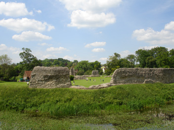
| The jagged remains of the 'curtain
wall' of Berkhamsted Castle (48 km SW of Royston) are shown in this
picture (as seen at 1305 GMT on 2nd June 2007). This castle is typical of
the 'motte-and-bailey' type of castle constructed after the Norman
Conquest. In the foreground is the Inner Moat and behind the photographer
the Outer Moat, whilst beyond the 'curtain wall' is the large grassy area
or 'bailey'. Although this day was cloudless at Royston (sunshine 15.8
hours), in the early afternoon a band of broken cloud developed from
Hampshire to Yorkshire and this affected Berkhamsted curtailing sunshine
at times. It was nonetheless a very pleasant early Summer day with the
temperature reaching a maximum of 24.1°C at Royston. |
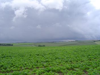
The shower cloud visible in this view
from Poors Land (some 3 km SE of Royston) at 0754 GMT on 16th June 2007 set
the tone for the rest of the day's weather as showers occurred at
various times during the day, yielding a rainfall total of 3.1 millimetres.
The village of Great Chishill is set on the distant ridge whilst the
village of Barley nestles beyond the nearer ridge in the right background.
Just two days earlier, on 14th, an intense storm cell in the late
afternoon caused flash flooding in Barley whereas Royston largely escaped
this deluge but did experience heavy showers and frequent thunder at this
time. (At time of photograph wind S, mean speed 3 knots gusting to 10
knots, temperature 15.4°C).
|
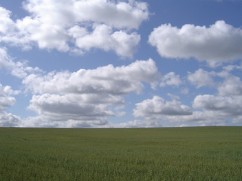
Only two features are visible in this
picture, a sky studded with cumulus cloud and a large acreage of growing
oats! This was the scene not far from Heath Farm SE of Royston on 26th
June 2007 at 0831 GMT and is typical of the 'prairie' type landscape
skirting the northern edge of the East Anglian Heights notably between
Baldock and Royston and continuing a little further to the east. Barley,
wheat, oats and oilseed rape are currently the main crops cultivated on
these large open stretches of country. Just half an hour later at 0900 GMT
the cloud had increased to 6 oktas and not much sunshine occurred
thereafter (daily total 2.0 hours). It was a very cool day, the maximum
temperature being only 14.4°C (5.5°C below average). |
Return to Welcome
to Royston (Iceni) Weather Station page
(This page last updated 17th July 2007 2014 GMT)