Royston (Iceni) Weather Station
Daily Weather Observations - January 2012
(All Times GMT)
| Date | Max. Temp. (°C) 09/09h | Min. Temp. (°C) 09/09h | Grass Min. Temp. (°C) 21/09h | Earth (30cms) Temp. (°C) 09h | Sun (Hours) 00/00h | R'fall (MM) 09/09h | Wind Dir'n 09h | Mean Wind Speed (MPH) 00/00h | Max. Gust Speed (MPH) 00/00h | Cloud Cover (Oktas) 09h | Mean MSL Air Pressure (mB) 00/00h | Mean Rel. Humd. (%) 00/00h | Mean Temp. (°C) 00/00h | Fog (vis. <1000m @ 09h) | Fog (vis. <200m @ 09h) | Snow or Rain and Snow 00/00h | Snow Lying @ 09h (>50% cover) | Hail 00/00h | Thunder 00/00h | Date |
| 1 | 11.8 | 10.9 | 9.0 | 7.7 | 0.1 | 1.5 | S | 9.3 | 27 | 8 | 1003.1 | 88.3 | 10.6 | 0 | 0 | 0 | 0 | 0 | 0 | 1 |
| 2 | 11.9 | 3.5 | 1.6 | 7.5 | 6.4 | 2.2 | SW | 11.5 | 29 | 1 | 1006.7 | 82.8 | 5.0 | 0 | 0 | 0 | 0 | 0 | 0 | 2 |
| 3 | 12.1 | 4.2 | 3.5 | 6.5 | 1.0 | 4.8 | SW | 18.0 | 51 | 8 | 1000.0 | 84.7 | 7.4 | 0 | 0 | 0 | 0 | 0 | 0 | 3 |
| 4 | 10.9 | 4.0 | 1.8 | 6.3 | 0.0 | 4.8 | SW | 16.5 | 44 | 7 | 1010.9 | 80.2 | 6.3 | 0 | 0 | 0 | 0 | 0 | 0 | 4 |
| 5 | 8.5 | 5.7 | 4.0 | 6.6 | 2.6 | 0.2 | NW | 16.3 | 50 | 7 | 1002.8 | 80.3 | 7.5 | 0 | 0 | 0 | 0 | 0 | 0 | 5 |
| 6 | 9.9 | 1.5 | -1.0 | 6.0 | 6.4 | 0.5 | W | 8.7 | 28 | 1 | 1022.2 | 87.7 | 5.1 | 0 | 0 | 0 | 0 | 0 | 0 | 6 |
| 7 | 9.0 | 7.4 | 4.2 | 6.0 | 0.4 | 0.0 | W | 10.5 | 29 | 7 | 1020.2 | 78.7 | 8.1 | 0 | 0 | 0 | 0 | 0 | 0 | 7 |
| 8 | 9.4 | 7.0 | 6.1 | 6.4 | 0.1 | TR | NW | 7.7 | 19 | 8 | 1025.3 | 81.1 | 8.0 | 0 | 0 | 0 | 0 | 0 | 0 | 8 |
| 9 | 11.5 | 6.9 | 5.0 | 6.7 | 0.6 | 0.0 | SW | 7.5 | 22 | 7 | 1028.4 | 85.8 | 9.3 | 0 | 0 | 0 | 0 | 0 | 0 | 9 |
| 10 | 10.5 | 7.7 | 5.2 | 7.2 | 1.0 | 0.0 | SW | 7.5 | 26 | 8 | 1031.8 | 87.5 | 8.9 | 0 | 0 | 0 | 0 | 0 | 0 | 10 |
| 11 | 11.5 | 6.9 | 5.0 | 7.1 | 5.0 | 0.0 | SW | 9.3 | 22 | 0 | 1031.2 | 88.2 | 8.6 | 0 | 0 | 0 | 0 | 0 | 0 | 11 |
| 12 | 11.5 | 7.5 | 5.7 | 7.1 | 4.3 | 0.0 | SW | 10.6 | 31 | 8 | 1026.1 | 84.5 | 7.9 | 0 | 0 | 0 | 0 | 0 | 0 | 12 |
| 13 | 5.8 | 0.6 | -2.9 | 6.4 | 6.4 | 0.0 | W | 2.8 | 13 | 5 | 1032.4 | 88.9 | 2.1 | 0 | 0 | 0 | 0 | 0 | 0 | 13 |
| 14 | 5.0 | -3.1 | -7.3 | 5.0 | 6.8 | 0.0 | CALM | 1.0 | 11 | 0 | 1029.8 | 89.9 | -0.2 | 0 | 0 | 0 | 0 | 0 | 0 | 14 |
| 15 | 5.6 | -0.2 | -5.0 | 4.2 | 3.7 | 0.0 | SE | 1.9 | 16 | 7 | 1025.0 | 84.3 | 2.1 | 0 | 0 | 0 | 0 | 0 | 0 | 15 |
| 16 | 6.5 | -2.1 | -7.0 | 3.9 | 7.0 | 0.0 | SE | 2.2 | 12 | 0 | 1025.7 | 86.8 | 0.8 | 0 | 0 | 0 | 0 | 0 | 0 | 16 |
| 17 | 8.0 | -1.0 | -5.8 | 3.4 | 4.4 | 0.4 | S | 4.6 | 22 | 2 | 1026.9 | 84.6 | 1.7 | 0 | 0 | 0 | 0 | 0 | 0 | 17 |
| 18 | 11.3 | 2.0 | -0.3 | 3.3 | 0.0 | 12.4 | S | 9.9 | 30 | 8 | 1022.2 | 95.2 | 8.3 | 0 | 0 | 0 | 0 | 0 | 0 | 18 |
| 19 | 8.5 | 6.0 | 5.4 | 5.0 | 2.6 | 0.9 | W | 8.4 | 33 | 8 | 1017.1 | 90.6 | 7.3 | 0 | 0 | 0 | 0 | 0 | 0 | 19 |
| 20 | 10.5 | 3.0 | 0.8 | 5.0 | 0.0 | 6.1 | W | 11.2 | 27 | 8 | 1017.3 | 89.2 | 6.0 | 0 | 0 | 0 | 0 | 0 | 0 | 20 |
| 21 | 11.4 | 7.2 | 6.1 | 5.6 | 1.5 | 0.7 | W | 12.6 | 37 | 6 | 1010.4 | 84.1 | 8.6 | 0 | 0 | 0 | 0 | 0 | 0 | 21 |
| 22 | 10.4 | 4.9 | 2.8 | 5.8 | 2.3 | 0.0 | SW | 13.5 | 40 | 4 | 1012.5 | 75.9 | 6.9 | 0 | 0 | 0 | 0 | 0 | 0 | 22 |
| 23 | 8.1 | 4.4 | 2.7 | 5.5 | 3.6 | 1.3 | W | 7.6 | 20 | 7 | 1017.6 | 82.5 | 5.2 | 0 | 0 | 0 | 0 | 0 | 0 | 23 |
| 24 | 9.5 | 1.6 | -1.6 | 5.0 | 0.1 | 2.0 | S | 6.2 | 25 | 8 | 1018.1 | 93.4 | 5.6 | 0 | 0 | 0 | 0 | 0 | 0 | 24 |
| 25 | 9.4 | 8.1 | 7.2 | 5.9 | 0.0 | 3.8 | SW | 7.4 | 31 | 8 | 1013.8 | 90.4 | 8.7 | 0 | 0 | 0 | 0 | 0 | 0 | 25 |
| 26 | 8.2 | 5.4 | 4.6 | 6.5 | 3.9 | 0.3 | S | 8.8 | 30 | 7 | 1007.7 | 86.5 | 5.8 | 0 | 0 | 0 | 0 | 0 | 0 | 26 |
| 27 | 7.7 | 1.4 | -0.5 | 5.7 | 7.1 | 0.8 | SW | 8.6 | 22 | 0 | 1017.8 | 85.3 | 3.8 | 0 | 0 | 0 | 0 | 0 | 0 | 27 |
| 28 | 6.1 | 2.0 | -0.1 | 5.3 | 0.7 | 0.1 | N | 2.4 | 14 | 8 | 1028.2 | 91.1 | 3.3 | 0 | 0 | 0 | 0 | 0 | 0 | 28 |
| 29 | 3.4 | 0.3 | -1.9 | 5.0 | 0.0 | 0.0 | N | 1.3 | 12 | 8 | 1030.7 | 93.9 | 1.7 | 1 | 1 | 0 | 0 | 0 | 0 | 29 |
| 30 | 3.5 | 0.0 | -1.9 | 5.0 | 0.1 | 0.0 | E | 1.3 | 11 | 8 | 1025.9 | 89.2 | 1.4 | 0 | 0 | 1 | 0 | 0 | 0 | 30 |
| 31 | 1.8 | -0.5 | -2.9 | 4.8 | 0.8 | TR | E | 2.9 | 15 | 8 | 1026.6 | 89.7 | 0.2 | 0 | 0 | 0 | 0 | 0 | 0 | 31 |
| Total/Mean | 8.7 | 3.7 | 1.4 | 5.7 | 78.7 | 42.8 | X | 8.0 | X | 5.8 | 1019.8 | 86.5 | 5.5 | 1 | 1 | 1 | 0 | 0 | 0 | Total/Mean |
| *Diff./% | +1.8 | +1.2 | 121% | 84% | *Diff./% | |||||||||||||||
| Date | Max. Temp. (°C) 09/09h | Min. Temp. (°C) 09/09h | Grass Min. Temp. (°C) 21/09h | Earth (30cms) Temp. (°C) 09h | Sun (Hours) 00/00h | R'fall (MM) 09/09h | Wind Dir'n 09h | Mean Wind Speed (MPH) 00/00h | Max. Gust Speed (MPH) 00/00h | Cloud Cover (Oktas) 09h | Mean MSL Air Pressure (mB) 00/00h | Mean Rel. Humd. (%) 00/00h | Mean Temp. (°C) 00/00h | Fog (vis. <1000m @ 09h) | Fog (vis. <200m @ 09h) | Snow or Rain and Snow 00/00h | Snow Lying @ 09h (>50% cover) | Hail 00/00h | Thunder 00/00h | Date |
Differences from average:
Differences from average shown in red. Reference periods used are as follows: Temperature 30 Years 1981/2010; rainfall 30 Years 1981/2010; sunshine 30 Years 1971/2000.
(*The differences from average quoted during the course of the month relate to the cumulative daily averages up to the date of the last observation, not the averages for the month as a whole)
Additional Data:
Rainfall Duration N/A
Air Frost Duration 43.6 hours
Graphs and Charts:
Click on the following links to view this month's graphs and charts.....
1. Daily Maximum, Minimum & Grass Minimum Temperatures
2. Daily Maximum & Minimum Temperatures (with 30 Year Comparative Means)
3. Daily Earth (30 cms Depth) Temperature @ 0900 GMT 4. Daily Rainfall 5. Daily Sunshine
6. Daily Maximum Gust & Mean Wind Speed 7. Daily Wind Direction @ 0900 GMT
8. Daily Mean MSL Air Pressure 9. Daily Mean Relative Humidity 10. Thermograph
11. Barograph 12. Hygrograph 13. Anemograph 14. Wind Direction
15. Rainfall Intensity & Duration
January 2012 Weather Review:
......and click on the link below for a text report of the January 2012 weather in Royston
January (since 1973) at Royston (Iceni) Weather Station:
Mean day maximum temperature (30 years 1981/2010) 6.9°C
Mean night minimum temperature (30 years 1981/2010) 2.5°C
Highest temperature 14.2°C (6th January 1999); lowest temperature -12.7°C (14th January 1982)
Lowest grass minimum temperature -18.1°C (10th January 1982)
Warmest January 2007, 2008 (Mean temperature 7.4°C); coldest January 1979 (Mean temperature 0.1°C)
Average January rainfall (30 years 1981/2010) 51.2 mm
Wettest January 1995 (Rainfall 108.2 mm); driest January 1987 (Rainfall 9.6 mm)
Wettest Day 9th January 1992 (Rainfall 25.1 mm);
Highest number of "rain days" (0.2 mm or more) 25 (1988, 2004); lowest number of "rain days" 9 (1992)
Highest number of days with thunder 1 (1974, 1984. 1988, 1994, 1998 and 2004)
Highest number of air frosts 20 (1979, 1985)
Highest number of ground frosts 25 (1979)
Highest number of days with snow falling 15 (1985)
Highest number of days with snow lying (ground with more than 50% snow cover @ 0900 GMT) 17 (1985)
|
|
|
|
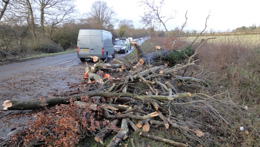
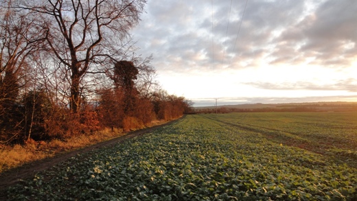
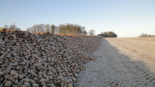
| In the morning of 5th January 2012 strong winds brought down several trees in the Royston are and in this picture of the A505 road 2 km east of Royston a large tree has fallen across the carriageway. Eastbound traffic was completely blocked for a time whilst westbound vehicles managed to slowly pass by only to be faced with a another blockage further along the road. At the time of this photograph (0856 GMT) the WNW wind was of mean speed 17 knots gusting to 30 knots, but a little earlier at 0740 GMT a gust of 43.5 knots (50 mph) had been recorded. A cold front had crossed the area at about 0600 GMT in a steep pressure gradient between low pressure over northern Denmark and an anticyclone west of Portugal. Nearby on the opposite side of the road a large tree was blown over, falling away from the carriageway but across the parallel Icknield Way footpath and bridleway. The temperature later rose to a maximum of 8.5°C, and accumulated sunshine for the day was 2.6 hours. | This was the scene along the Icknield Way approximately 2 km E of Royston at 0823 GMT on 10th January 2012. The early morning sun is casting an orange glow along the hedgerow in a temperature of 8.3°C, whilst a SW wind of mean speed 6 knots gusting to 11 knots is gently swaying the nearby tree branches. The Autumn sown green crop in evidence here has been widely sown across north Hertfordshire and south Cambridgeshire after last year's cereal harvest. Such a cover not only helps to smother germinating weeds but assists in preventing the nitrate leaching which may occur in a bare soil situation, and a successful crop cover will act as a nitrate 'bridge', enabling soil nitrogen to be preserved for the next crop after the green crop is ploughed in. This latter action can be expected to improve soil structure and increase humus levels and consequently increase the soil's capacity to hold water (especially important on the light chalk soil here). | A large field between Cow Plantation and the Barkway Road on the Burloes estate to the east of Royston was last year sown with sugar beet, which was harvested in the second week of January 2012. Here the abundant crop is seen piled high in a long formation parallel to the Barkway Road ready to be transported for processing before the end of the sugar campaign. As can be seen in the photograph (taken at 0859 GMT on 14th January 2012) frost is covering both the beet and the adjacent field from which it has just been extracted, and steam is rising from the top of the beet in the early morning sunshine. The temperature is -2.9°C, only slightly above the overnight minimum temperature of -3.1°C, and conditions are mainly calm with only the occasional interruption of minor gusts up to 2 knots in strength. At 1200 GMT that day an anticyclone of central pressure 1031 mB was virtually centred right over Royston! Sunshine for the day was 6.8 hours and the maximum temperature was 5.0°C. |
Return to Welcome to Royston (Iceni) Weather Station page
(This page last updated 9th February 2012 2130 GMT)