Royston (Iceni) Weather Station
Daily Weather Observations - January 2013
(All Times GMT)
| Date | Max. Temp. (°C) 09/09h | Min. Temp. (°C) 09/09h | Grass Min. Temp. (°C) 21/09h | Earth (30cms) Temp. (°C) 09h | Sun (Hours) 00/00h | R'fall (MM) 09/09h | Wind Dir'n 09h | Mean Wind Speed (MPH) 00/00h | Max. Gust Speed (MPH) 00/00h | Cloud Cover (Oktas) 09h | Mean MSL Air Pressure (mB) 00/00h | Mean Rel. Humd. (%) 00/00h | Mean Temp. (°C) 00/00h | Fog (vis. <1000m @ 09h) | Fog (vis. <200m @ 09h) | Snow or Rain and Snow 00/00h | Snow Lying @ 09h (>50% cover) | Hail 00/00h | Thunder 00/00h | Date |
| 1 | 6.8 | 3.1 | 0.4 | 7.0 | 6.3 | 0.0 | W | 9.2 | 26 | 0 | 1006.1 | 86.1 | 5.2 | 0 | 0 | 0 | 0 | 0 | 0 | 1 |
| 2 | 10.3 | 3.7 | 1.0 | 5.9 | 0.0 | 3.2 | SW | 8.8 | 24 | 8 | 1021.5 | 91.6 | 6.8 | 0 | 0 | 0 | 0 | 0 | 0 | 2 |
| 3 | 11.3 | 8.6 | 7.0 | 6.4 | 0.7 | 0.0 | W | 9.1 | 26 | 7 | 1030.8 | 96.2 | 9.6 | 0 | 0 | 0 | 0 | 0 | 0 | 3 |
| 4 | 9.5 | 8.7 | 7.9 | 7.0 | 3.1 | 0.1 | W | 7.3 | 21 | 8 | 1035.6 | 91.9 | 8.8 | 0 | 0 | 0 | 0 | 0 | 0 | 4 |
| 5 | 11.1 | 7.4 | 7.0 | 7.1 | 1.8 | 0.0 | SW | 6.6 | 21 | 8 | 1033.6 | 93.6 | 8.6 | 0 | 0 | 0 | 0 | 0 | 0 | 5 |
| 6 | 9.4 | 5.2 | 0.2 | 7.0 | 0.0 | 0.1 | SW | 5.3 | 18 | 8 | 1030.7 | 95.5 | 7.8 | 1 | 0 | 0 | 0 | 0 | 0 | 6 |
| 7 | 9.0 | 6.5 | 6.0 | 7.3 | 0.0 | 0.0 | S | 6.8 | 20 | 8 | 1025.2 | 94.0 | 7.6 | 0 | 0 | 0 | 0 | 0 | 0 | 7 |
| 8 | 10.9 | 7.4 | 5.4 | 7.3 | 2.3 | 4.4 | SW | 7.3 | 20 | 8 | 1022.4 | 91.1 | 9.3 | 0 | 0 | 0 | 0 | 0 | 0 | 8 |
| 9 | 8.1 | 6.0 | 5.8 | 7.6 | 5.9 | 0.1 | N | 3.2 | 15 | 7 | 1020.3 | 93.9 | 5.7 | 0 | 0 | 0 | 0 | 0 | 0 | 9 |
| 10 | 2.3 | -0.3 | -2.9 | 6.4 | 0.0 | 0.1 | W | 4.1 | 14 | 8 | 1014.9 | 97.6 | 1.1 | 1 | 1 | 0 | 0 | 0 | 0 | 10 |
| 11 | 4.0 | 0.7 | 0.9 | 6.0 | 0.0 | 0.0 | W | 3.4 | 14 | 8 | 1016.8 | 98.1 | 2.1 | 0 | 0 | 0 | 0 | 0 | 0 | 11 |
| 12 | 4.4 | 0.1 | -2.9 | 5.4 | 0.2 | 0.0 | E | 4.0 | 21 | 7 | 1013.4 | 87.5 | 1.8 | 0 | 0 | 0 | 0 | 0 | 0 | 12 |
| 13 | 1.2 | -3.1 | -7.5 | 4.8 | 1.1 | 1.4 | NE | 1.1 | 7 | 8 | 1019.0 | 90.8 | -1.1 | 0 | 0 | 0 | 0 | 0 | 0 | 13 |
| 14 | 1.1 | -2.0 | -5.1 | 4.0 | 0.1 | 2.5 | S | 6.0 | 22 | 8 | 1009.7 | 93.7 | -0.1 | 0 | 0 | 1 | 1 | 0 | 0 | 14 |
| 15 | 1.0 | -0.7 | -3.0 | 3.9 | 0.1 | TR | NW | 4.5 | 24 | 8 | 1008.6 | 95.4 | -0.2 | 0 | 0 | 1 | 1 | 0 | 0 | 15 |
| 16 | -2.7 | -4.5 | -8.7 | 3.8 | 0.0 | TR | W | 1.1 | 7 | 8 | 1013.1 | 96.6 | -3.6 | 1 | 1 | 1 | 1 | 0 | 0 | 16 |
| 17 | 0.3 | -7.5 | -11.0 | 3.5 | 4.3 | 0.0 | W | 2.0 | 12 | 1 | 1016.9 | 94.8 | -3.2 | 0 | 0 | 0 | 1 | 0 | 0 | 17 |
| 18 | -0.5 | -2.6 | -3.0 | 3.2 | 0.0 | 2.7 | SE | 5.3 | 22 | 8 | 1003.8 | 90.6 | -1.7 | 0 | 0 | 1 | 1 | 0 | 0 | 18 |
| 19 | -0.2 | -1.5 | -1.4 | 3.0 | 0.0 | 0.2 | NE | 4.7 | 18 | 8 | 997.8 | 92.3 | -0.9 | 0 | 0 | 1 | 1 | 0 | 0 | 19 |
| 20 | -0.3 | -2.0 | -2.3 | 3.0 | 0.0 | 7.9 | NE | 4.3 | 16 | 8 | 994.6 | 91.8 | -1.0 | 0 | 0 | 1 | 1 | 0 | 0 | 20 |
| 21 | 0.1 | -1.6 | -1.7 | 3.0 | 0.0 | TR | E | 3.3 | 13 | 8 | 993.8 | 94.2 | -0.9 | 0 | 0 | 1 | 1 | 0 | 0 | 21 |
| 22 | 1.6 | -5.4 | -10.0 | 3.0 | 0.0 | 0.1 | SE | 2.8 | 14 | 8 | 1002.1 | 93.6 | -1.0 | 0 | 0 | 1 | 1 | 0 | 0 | 22 |
| 23 | 0.9 | -0.6 | -1.4 | 3.0 | 0.0 | TR | NE | 3.1 | 14 | 8 | 1008.2 | 89.5 | 0.2 | 0 | 0 | 1 | 1 | 0 | 0 | 23 |
| 24 | 1.3 | -1.0 | -1.4 | 3.0 | 0.0 | 0.0 | NE | 1.4 | 10 | 7 | 1016.5 | 87.0 | 0.0 | 0 | 0 | 0 | 1 | 0 | 0 | 24 |
| 25 | 2.2 | -3.5 | -8.0 | 3.0 | 0.0 | 3.0 | S | 6.8 | 27 | 8 | 1012.9 | 87.1 | -0.8 | 0 | 0 | 1 | 1 | 0 | 0 | 25 |
| 26 | 9.8 | 0.5 | -1.1 | 2.9 | 6.0 | 8.0 | W | 9.8 | 39 | 1 | 1004.5 | 92.0 | 3.3 | 0 | 0 | 1 | 1 | 0 | 0 | 26 |
| 27 | 8.8 | 6.0 | 4.8 | 3.4 | 6.4 | 0.0 | SW | 15.1 | 38 | 3 | 995.3 | 82.0 | 7.0 | 0 | 0 | 0 | 0 | 0 | 0 | 27 |
| 28 | 10.6 | 2.0 | 0.1 | 3.5 | 1.4 | 1.6 | S | 13.2 | 45 | 1 | 1002.8 | 85.8 | 5.9 | 0 | 0 | 0 | 0 | 0 | 0 | 28 |
| 29 | 13.8 | 8.6 | 7.0 | 4.4 | 0.0 | 5.7 | S | 14.2 | 38 | 8 | 1000.3 | 87.4 | 11.4 | 0 | 0 | 0 | 0 | 0 | 0 | 29 |
| 30 | 10.9 | 8.2 | 6.4 | 6.0 | 6.4 | 1.6 | SW | 14.4 | 37 | 7 | 1004.5 | 82.4 | 9.0 | 0 | 0 | 0 | 0 | 0 | 0 | 30 |
| 31 | 10.5 | 6.0 | 3.8 | 5.6 | 6.5 | 2.7 | SW | 15.4 | 39 | 3 | 1009.3 | 77.8 | 7.9 | 0 | 0 | 0 | 0 | 0 | 0 | 31 |
| Total/Mean | 5.4 | 1.7 | -0.2 | 4.9 | 52.5 | 45.4 | X | 6.6 | X | 6.6 | 1012.4 | 91.0 | 3.4 | 3 | 2 | 11 | 13 | 0 | 0 | Total/Mean |
| *Diff./% | -1.5 | -0.8 | 81% | 89% | *Diff./% | |||||||||||||||
| Date | Max. Temp. (°C) 09/09h | Min. Temp. (°C) 09/09h | Grass Min. Temp. (°C) 21/09h | Earth (30cms) Temp. (°C) 09h | Sun (Hours) 00/00h | R'fall (MM) 09/09h | Wind Dir'n 09h | Mean Wind Speed (MPH) 00/00h | Max. Gust Speed (MPH) 00/00h | Cloud Cover (Oktas) 09h | Mean MSL Air Pressure (mB) 00/00h | Mean Rel. Humd. (%) 00/00h | Mean Temp. (°C) 00/00h | Fog (vis. <1000m @ 09h) | Fog (vis. <200m @ 09h) | Snow or Rain and Snow 00/00h | Snow Lying @ 09h (>50% cover) | Hail 00/00h | Thunder 00/00h | Date |
Differences from average:
Differences from average shown in red. Reference periods used are as follows: Temperature 30 Years 1981/2010; rainfall 30 Years 1981/2010; sunshine 30 Years 1981/2010.
(*The differences from average quoted during the course of the month relate to the cumulative daily averages up to the date of the last observation, not the averages for the month as a whole)
Additional Data:
Rainfall Duration N/A
Air Frost Duration 226.0 hours
Graphs and Charts:
Click on the following links to view this month's graphs and charts.....
1. Daily Maximum, Minimum & Grass Minimum Temperatures
2. Daily Maximum & Minimum Temperatures (with 30 Year Comparative Means)
3. Daily Earth (30 cms Depth) Temperature @ 0900 GMT 4. Daily Rainfall 5. Daily Sunshine
6. Daily Maximum Gust & Mean Wind Speed 7. Daily Wind Direction @ 0900 GMT
8. Daily Mean MSL Air Pressure 9. Daily Mean Relative Humidity 10. Thermograph
11. Barograph 12. Hygrograph 13. Anemograph 14. Wind Direction
15. Rainfall Intensity & Duration
January 2013 Weather Review:
......and click on the link below for a text report of the January 2013 weather in Royston
January (since 1973) at Royston (Iceni) Weather Station:
Mean day maximum temperature (30 years 1981/2010) 6.9°C
Mean night minimum temperature (30 years 1981/2010) 2.5°C
Highest temperature 14.2°C (6th January 1999); lowest temperature -12.7°C (14th January 1982)
Lowest grass minimum temperature -18.1°C (10th January 1982)
Warmest January 2007, 2008 (Mean temperature 7.4°C); coldest January 1979 (Mean temperature 0.1°C)
Average January rainfall (30 years 1981/2010) 51.2 mm
Wettest January 1995 (Rainfall 108.2 mm); driest January 1987 (Rainfall 9.6 mm)
Wettest Day 9th January 1992 (Rainfall 25.1 mm);
Highest number of "rain days" (0.2 mm or more) 25 (1988, 2004); lowest number of "rain days" 9 (1992)
Highest number of days with thunder 1 (1974, 1984. 1988, 1994, 1998 and 2004)
Highest number of air frosts 20 (1979, 1985)
Highest number of ground frosts 25 (1979)
Highest number of days with snow falling 15 (1985)
Highest number of days with snow lying (ground with more than 50% snow cover @ 0900 GMT) 17 (1985)
|
|
|
|
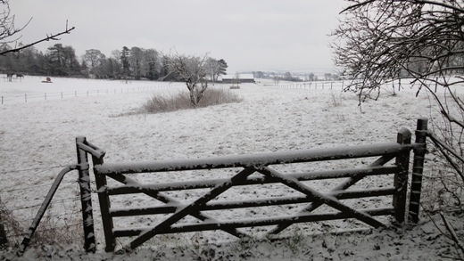
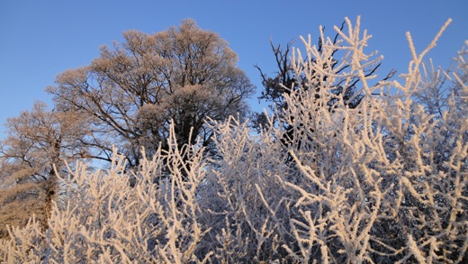
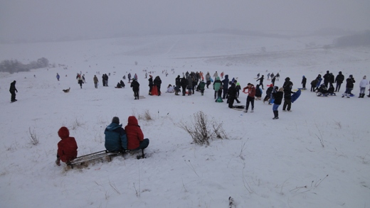
| The first snowfall of the year 2013 in Royston occurred on 14th January and this ushered in a cold and snowy spell which lasted almost 2 weeks. Over this period 10 days registered 24 hour mean temperatures below 0°C, and daily maximum temperatures failed to reach 0°C on 4 days. Whilst the level depth of snow at 0900 GMT on 14th was only 2 cm further falls of snow increased this depth to 13 cm by 0900 GMT on 21st. This was the scene looking SSE from the Greenwich Meridian on the Burloes estate to the east of Royston at 0919 GMT. Normally the village of Great Chishill on the East Anglian Heights can be seen from this vantage point but on this day the visibility was too poor for a clear view. The temperature at this time was -0.9°C, rising to a maximum of 1.1°C later in the day, with a S wind of mean speed 5 knots gusting to 9 knots. The adjacent field to the W has been cordoned off for the introduction of sheep to feed on the green crop grown after last summer's cereal harvest. Sunshine on 14th was at an absolute premium, only half a minute! | On 17th January the countryside around Royston and much further afield into Cambridgeshire and Bedfordshire was clothed in a thick coating of hoar frost, in addition to a 2 cm snow cover. This picture was taken close to Heath Farm, Royston at 0829 GMT, and shortly before this the rising sun had tinged the hoar frost on the hedgerows with an orange glow. The temperature is -7.1°C in calm conditions, falling to a minimum of -7.5°C at 0845 GMT, this being the lowest temperature of the Winter so far. Assisted by bright sunshine a remarkable rise in temperature then occurred up to a maximum of 0.3°C by 1300 GMT. This had the effect of melting the frost on the trees and hedgerows, whereas in the cloudier areas to the NW of Royston the landscape had still retained its frost cover by the end of the day. Sunshine for the day was 4.3 hours, but then followed a highly unusual scenario (even for Winter) of 8 consecutive days without a single ray of sunshine. Consequently, by 25th the January sunshine was running at less than half the normal for the month up to that date. | Despite continuous snowfall, albeit fairly light in nature, poor visibilty, and a temperature hovering around 0°C, many people were attracted to Therfield Heath, Royston on 20th January to take advantage of the numerous sledging runs down into the dry valleys of the area. In this picture looking in an ESE direction from a vantage point close to the Long Barrow towards the eastern end of the Heath one of the main runs is in view. Beyond the valley in the middle distance runs the Icknield Way Trail to the village of Therfield and beyond. A fairly light air of mean speed 4 knots gusting to 7 knots was traversing the Heath from the NNE at this time, in a temperature of -0.1°C. The snow falling on this day increased the existing 6 cm level cover by a further 7 cm, the rainfall equivalent being 7.9 millimetres, this being the highest daily total in a dry month so far. A maximum temperature of only 0.1°C was achieved on 20th, but the continuous cloud cover prevented the temperature falling below -1.6°C in the overnight period. |
Return to Welcome to Royston (Iceni) Weather Station page
(This page last updated 8th February 2013 2103 GMT)